Blog

He & She Eat Clean | Healthy Recipes & Workout Plans

trip report

Devils Garden Primitive Loop (Arches National Park)

TravelWhitney CarlsonComment
Hiking Devils Garden Primitive Loop (Arches National Park)

Devils Garden Primitive Loop
Arches National Park

  • Trailhead Location: Devils Garden Trailhead

(Latitude, Longitude: 38.783179, -109.594930)

  • Payoff Factor: 4

(1 being “A complete waste of time and energy”, 5 being “The payoff is definitely worth the effort“)

  • Difficulty Factor: 2 (only a couple difficult sections with some exposure to heights)

1 being your Grandma can do this hike, 5 being you’ll feel like your Grandma when this hike is over)

  • Length (Distance): 7.4 miles round-trip
  • Length (Time): 3.5 - 5 hours (with stops at all arches)
  • Cumulative Elevation Gain: 1,100 feet (5,160 lowest, 5,487 highest)
Hiking Devils Garden Primitive Loop (Arches National Park)

Keep your eyes open for wildlife, like this snake slithering back into his hole!

Hiking Devils Garden Primitive Loop (Arches National Park)

Ignore our tired faces! At this point, we had been hiking non-stop for a week and it was super early in the morning (to beat the crowds!)

Hiking Devils Garden Primitive Loop (Arches National Park)

Trip Report:

This was our favorite hike in Arches National Park and in the general area of Moab, Utah.  There are amazing sites to see at regular intervals (which is great for my ADD) and interesting routes that take you along the spine of slickrock fins with mesmerizing pinnacles and endless interesting rock gardens in all directions.  Make it a point to get to the trailhead just after sunset as there were literally over 100 people starting the hike when we finished around 10:30 a.m.  Had we started around that time, it wouldn’t have been worth it to hike the loop although I imagine that most people turn around and return to their vehicles after viewing the Landscape Arch.

As with all hikes in the desert, there is minimal shade and maximal sunlight, so bring plenty of water (around 3 Liters per person) and apply sunscreen and/or protective clothing to shield the sunlight.

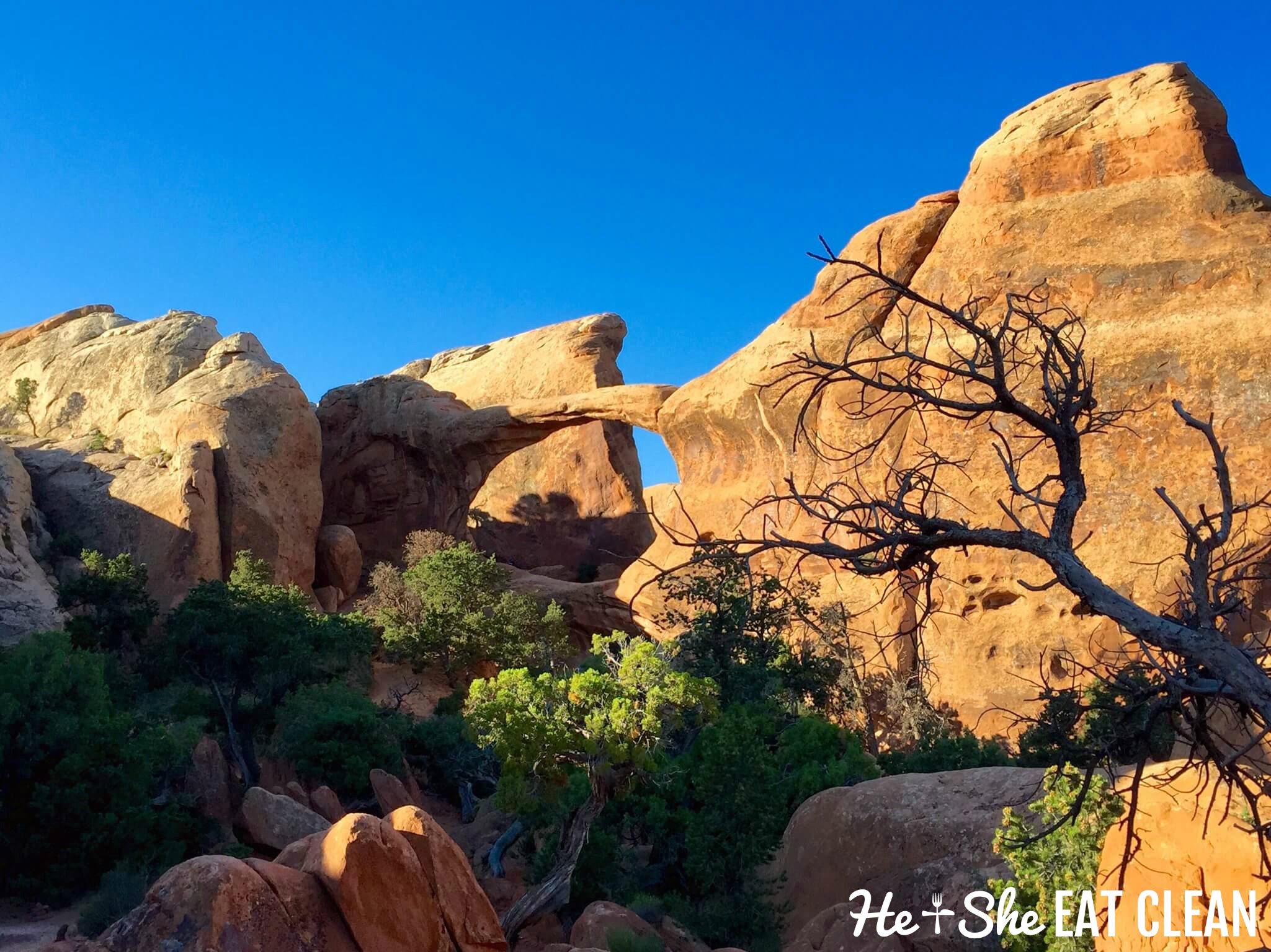
For a 7+ mile hike, there is a lot of action packed into this trail - seven named arches and one optional spur trail to a 150’ monolith named “Dark Angel”.  Once you get past Landscape Arch, you will see a NPS sign warning, “Caution, primitive trail, difficult hiking;”  maybe this is to warn the massive amount of people hiking to Landscape Arch not to venture onto the slickrock spines or fins, but the trail is not overly difficult…if you have any experience in the backcountry, do not back down - the little degree difficulty is definitely worth it!

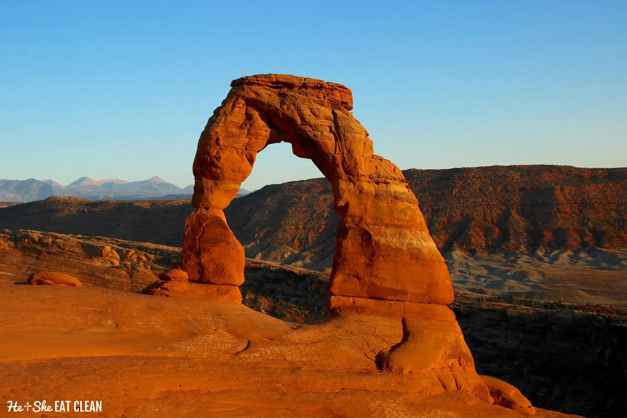
We completed this hike in a clockwise manner with a visit to Landscape Arch first (before visiting Tunnel and Pine Tree Arches) in order to view the arch with favorable morning sunlight which makes for an amazing photographic opportunity against the vivid blue Utah sky.  This is definitely the most advisable route.

Hiking Devils Garden Primitive Loop (Arches National Park)

Here are the key highlights (mileage markers) for the Devils Garden Primitive Loop:

  • 0.0 - Start at northwest end of parking lot and follow solid gravel path
  • 0.3 - Reach the spur trail to Tunnel Arch and Pine Arch 
  • 1.4 - Reach Landscape Arch and the official start point of the primitive trail
  • 1.8 - Reach the spur trail for Partition Arch (0.18 miles) and Navajo Arch (0.33 miles)
  • 3.1 - Traverse the narrow spine of a fin with exposure to heights on both sides
  • 3.7 - Reach the Double O Arch (at trail left).  There is a spur trail that leads to Dark Angel - this trip report does not include this side trip.
  • 4.1 - Reach the spur trail to Private Arch (0.5 mile round-trip)
  • 5.3 - Criss-cross through the wash (sandy trail) and make the short climb up the trail for 0.2 mile to the prairie.
  • 6.5 - Join up with the Devils Garden Trail that took you to Landscape Arch.
  • 7.4 - Reach the parking lot after following the gravel path

Happy Trails!

- Scott

Delicate Arch (Arches National Park)

TravelWhitney CarlsonComment
Delicate Arch in Arches National Park | He and She Eat Clean

Trailhead Location: Wolfe Ranch parking area on the northern side of Delicate Arch Road

(Latitude, Longitude: 38.736069, -109.520643)

Payoff Factor: 4

(1 being “A complete waste of time and energy”, 5 being “The payoff is definitely worth the effort“)

Difficulty Factor: 2 (some sections are extremely steep, but along solid slickrock and minimal sand - be careful on the slickrock after the rare rain shower)

1 being your Grandma can do this hike, 5 being you’ll feel like your Grandma when this hike is over)

Length (Distance): 3.1 miles round-trip

Length (Time): 1.5 - 2 hours (with 30 minutes to spend at the arch)

Cumulative Elevation Gain: 714 feet - most coming on the last mile of the trail (4,227 lowest, 4,865 highest)


Perhaps Edward Abbey sums the mysterious beauty of Delicate Arch the most in his book, Desert Solitaire:

"A weird, lovely, fantastic object out of nature like Delicate Arch has the curious ability to remind us—like rock and sunlight and wind and wilderness—that out there is a different world, older and greater and deeper by far than ours, a world which surrounds and sustains the little world of men as sea and sky surround and sustain a ship. The shock of the real. For a little while we are again able to see, as the child sees, a world of marvels. For a few moments we discover that nothing can be taken for granted, for if this ring of stone is marvelous then all which shaped it is marvelous, and our journey here on earth, able to see and touch and hear in the midst of tangible and mysterious things-in-themselves, is the most strange and daring of all adventures."

Indeed, the grandeur of Delicate Arch will bring you back to the days when you first marveled at a beautiful site as a child...there's nothing on earth like this arch, so soak up the beauty and feel like a kid again!

Trip Report

This short and steep hike is a must-do if you’re visiting Arches National Park just north of Moab, Utah. It is highly recommended to make this short trek to catch the setting sun provide a dramatically contrasted orange and red glow on the beautiful arch which frames the picturesque (and often snow-capped) La Sal Mountains in the distance (the primary photo for this report was taken about 10 minutes before sunset).  

Note - there is one caveat that must be mentioned for this hike - no matter what time you go, expect crowds and endless amounts of people wanting their picture made underneath the arch.  If you must have your picture taken under the arch, do so swiftly and let others have their turn.  We saw one person have a least 10 pictures made over three to four trips under the arch, taking about five minutes each time.  If you’re looking for solitude…avoid this hike altogether or make your trip just after sunrise.

Also, don’t underestimate the difficulty…it is a short hike, but there will be no shade and you will need at least 2 liters of water per person due to the level of exertion and heat.  This does not have to be a difficult hike if you come prepared.

The trailhead is very easy to find…head 11.8 miles into the park (from the turn off US Highway 191) and turn right onto Delicate Arch Road.  The trailhead will be on your left after 1.2 miles.

The hike begins on the eastern end of the parking lot (just right of the pit toilets) and heads past the Wolfe Ranch which was established in 1898 and vacated about 20 years later (although it would be occupied by other residents until it was placed on the National Register of Historic Places in 1975).

After passing the Ranch, you will see a sign for a spur trail that heads to an ancient Ute petroglyph panel which clearly tells a story of a bighorn sheep hunt from horseback.  Definitely worth the side trip!

Once you’re back on the main trail, follow the well-defined trail for about 0.4 miles up to the large slab of slickrock and follow the cairns up to the left and through a somewhat sandy section of the trail.  

Once you climb back through the sandy section, head along a rock ledge with somewhat steep drop-offs to the left.  Don’t worry if you have a sever fear of heights…the trail is at least three feet wide and you have a nice rock wall to balance against on your right side.  After an easy 200 yard climb up the rock ledge, you arrive at Delicate Arch.  Stay a while and admire the amazing 52 foot arch that has been made famous by its depiction on the Utah state license plates!

Be careful on the way back down…the trail is very steep and can be hard on your knees…take your time and you will enjoy the quick descent.

"May your trails be crooked, winding, lonesome, dangerous, leading to the most amazing view. May your mountains rise into and above the clouds." (Edward Abbey)

Happy Trails!

- Scott

Ten Lakes (Yosemite National Park)

TravelWhitney Carlson2 Comments
Ten Lakes Basin and surrounding peaks on the descent to  the Ten Lakes Basin.

Ten Lakes Basin and surrounding peaks on the descent to  the Ten Lakes Basin.

Trailhead Location: Ten Lakes

About 11 miles west on Tioga Road from the end of Tenaya Lake - parking on both sides of the road (Latitude, Longitude - 37.858401, -119.577445)

Payoff Factor: 4.5

(1 being “Meh…”, 5 being “Hike? What hike?”)

Difficulty Factor: 3 (the climb from Half Moon Meadow is a 4)

(1 being your Grandma can do this hike, 5 being you’ll feel like your Grandma when this hike is over)

Length (Distance): 13.7 miles round-trip (this report includes a short side trip to an amazing view of Ten Lakes basin and two other lakes in the basin)

Shorter Options:

  • 12.6 miles - simply visit the first lake off the main trail and return from there
  • 11.0 miles - hike to the overlook that forks to the left just after Ten Lakes Pass (the short side trail you can see as you crest the pass)

Length (Time): 6-8 hours

Cumulative Elevation Gain: 3,228 feet

The amazing panoramic view of Ten Lakes Basin (center) and the Sierra Crest (far left).

The amazing panoramic view of Ten Lakes Basin (center) and the Sierra Crest (far left).

Trip Report:

When you arrive at the Ten Lakes trailhead, you will notice there is ample parking on both sides of Tioga Road.  Most of the people completing this trail will be doing it as an overnight or multi-night backpacking trip combined with other trails from the Tioga Road area.  While Ten Lakes would make for an excellent easy/moderate overnight trip with a good deal of top notch campsites to choose from (don't forget your permits), this trip report is for a day hike of about six to eight hours.

Half Moon Meadow is an excellent place to rest and refuel before you head up the pass.

Half Moon Meadow is an excellent place to rest and refuel before you head up the pass.

The Ten Lakes trail follows a somewhat straight line to the northeast from Tioga Road up to Half Moon Meadow followed by a steep climb up to Ten Lakes Pass and then descends east to the lakes within the Ten Lakes basin.  The trail is easy to follow, but pay close attention and keep an eye on the cairns when you are in the open granite sections.  Hikers have found their way off the trail somewhat easily in these sections in recent history (read the NPS release here about a couple backpackers that lost the trail in 2013).  

Just one of many High Sierra lakes in the Ten Lakes Basin.

Just one of many High Sierra lakes in the Ten Lakes Basin.

Moreover, the trail shows off a lot of Yosemite's diversity as it heads from the shady Upper Montane Forest through lodgepole pines and rid fir near the trailhead to the also shady Subalpine Forest (around Half Moon Meadow and Ten Lakes) and then on to the wide-open Alpine Zone near the Ten Lakes Pass, so bring some sunscreen for the heavily exposed section around the Alpine Zone.  Enjoy the smells of the conifers as you trek through the forest...this is one of my favorite features of Yosemite National Park.  Also, the views to the north and east after you crest the pass are simply amazing!

This trail should be divided into three separate sections:

  • Miles 0.0 - 4.3: The first section climbs gradually for just over four miles to Half Moon Meadow with partial views of Mt. Hoffman and the surrounding peaks (7,400ft to 8,800ft) along the way.  There is plenty of shade on this section, so enjoy it!  
    • You will come to a stream crossing and trail junction (White Wolf campground) at about two miles...head straight here to continue to Ten Lakes.
    • It is a good idea to do a short refuel at the meadow prior to heading up to the pass.  Early in the season you cross Yosemite Creek which can contain some swift water, but don't count on this being a reliable water source later in the summer.
  • Miles 4.3 - 4.9: The second (and most difficult) section follows a steep grade for about a mile with convenient switchbacks as it climbs to Ten Lakes Pass (8,800ft to 9,600ft).  There is an easy to follow side trail that forks left after the pass with superb views of the Ten Lakes Basin, the Sierra Crest and the Grand Canyon of the Tuolomne.  
    • This section is a reliable water source early in the season as there are a couple decent springs right off the trail before you leave the forest.  
    • There is a trail junction with Grant Lakes at the pass which heads a mile down towards Grant Lakes.
  • Miles 4.9 - 6.3: The third (and easiest) section descends for about a half mile from Ten Lakes Pass to the Ten Lakes Basin and heads around the largest lakes within the basin.

Follow the sections above in reverse as you head back to the trailhead to complete your hike.

Happy trails!

-Scott

Ten Lakes - Yosemite National Park